


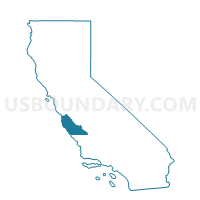
Voting District 30880, Monterey County, California
About
Outline

Summary
| Unique Area Identifier | 535294 |
| Name | Voting District 30880 |
| County | Monterey County |
| State | California |
| Area (square miles) | 23.42 |
| Land Area (square miles) | 22.01 |
| Water Area (square miles) | 1.41 |
| % of Land Area | 93.98 |
| % of Water Area | 6.02 |
| Latitude of the Internal Point | 36.37760400 |
| Longtitude of the Internal Point | -121.30407620 |
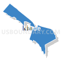
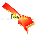
Maps


Graphs
Select a template below for downloading or customizing gragh for Voting District 30880, Monterey County, California


Neighbors
Neighoring Voting District (by Name) Neighboring Voting District on the Map
- Voting District 30615, Monterey County, CA
- Voting District 30620, Monterey County, CA
- Voting District 30625, Monterey County, CA
- Voting District 30690, Monterey County, CA
- Voting District 30700, Monterey County, CA
- Voting District 30705, Monterey County, CA
- Voting District 30790, Monterey County, CA
- Voting District 30840, Monterey County, CA
- Voting District 30845, Monterey County, CA
- Voting District 30855, Monterey County, CA
- Voting District 30860, Monterey County, CA
- Voting District 30865, Monterey County, CA
- Voting District 30885, Monterey County, CA
- Voting District 30905, Monterey County, CA
Top 10 Neighboring County Subdivision (by Population) Neighboring County Subdivision on the Map
- Gonzales CCD, Monterey County, CA (21,250)
- Greenfield CCD, Monterey County, CA (17,231)
- Soledad CCD, Monterey County, CA (16,642)
Top 10 Neighboring Place (by Population) Neighboring Place on the Map
Top 10 Neighboring Elementary School District (by Population) Neighboring Elementary School District on the Map
- Greenfield Union Elementary School District, CA (17,468)
- King City Union Elementary School District, CA (15,903)
- Mission Union Elementary School District, CA (307)
Top 10 Neighboring Secondary School District (by Population) Neighboring Secondary School District on the Map
Top 10 Neighboring Unified School District (by Population) Neighboring Unified School District on the Map
Top 10 Neighboring State Legislative District Lower Chamber (by Population) Neighboring State Legislative District Lower Chamber on the Map
Top 10 Neighboring State Legislative District Upper Chamber (by Population) Neighboring State Legislative District Upper Chamber on the Map
Top 10 Neighboring 111th Congressional District (by Population) Neighboring 111th Congressional District on the Map
Top 10 Neighboring Census Tract (by Population) Neighboring Census Tract on the Map
- Census Tract 111.02, Monterey County, CA (11,454)
- Census Tract 109, Monterey County, CA (10,109)
- Census Tract 148, Monterey County, CA (6,112)
- Census Tract 111.01, Monterey County, CA (5,188)
- Census Tract 108.04, Monterey County, CA (5,029)
- Census Tract 112.04, Monterey County, CA (3,190)